Publications
Peer-reviewed articles, book chapters, and conference proceedings
Peer-Reviewed Articles (First/Last Author)
Four Decades of Satellite Observations Reveal Climate-Driven Shifts and Spatial Heterogeneity in Shallow Lake Chlorophyll-a Dynamics
2026Water Research 289:124925
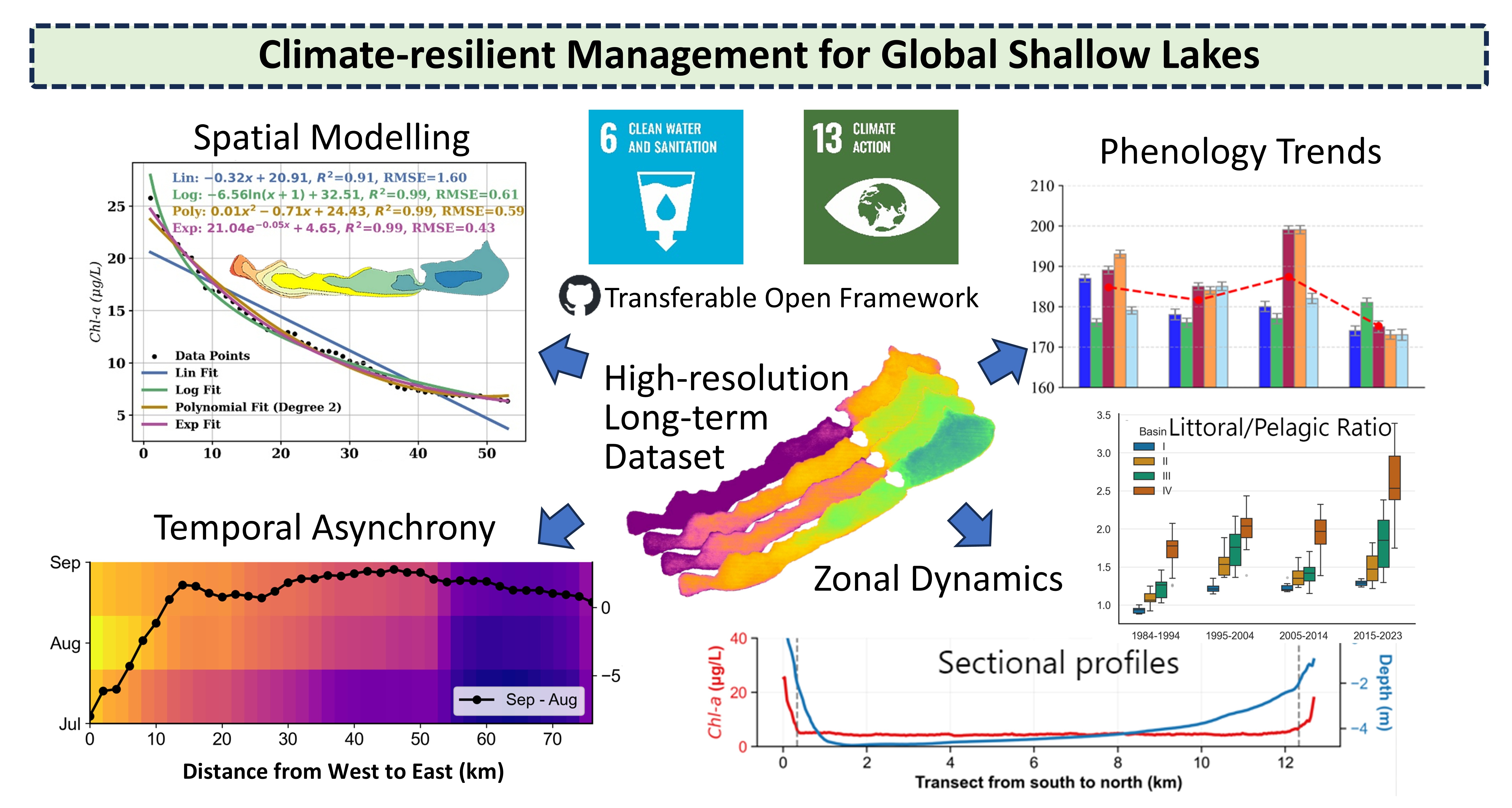
Graphical Abstract: 40 years of Landsat observations reveal climate-driven shifts in shallow lake chlorophyll-a dynamics
Leveraging Landsat and Google Earth Engine for long-term chlorophyll-a monitoring: A case study of Lake Balaton's water quality
2025Ecological Informatics 90, 103245
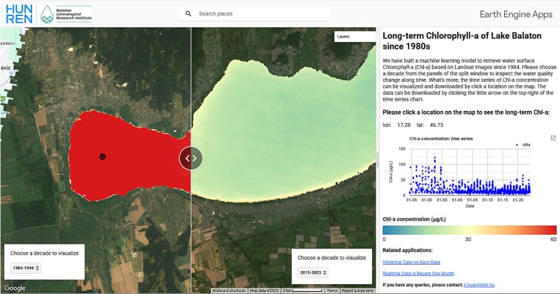
The interactive online application generated with GEE for inspecting long-term Chl-a and comparing decadal Chl-a dynamics
A framework for assessing the impact trends of neglecting water surface evaporation and substituting streamflow on water budget closure
2026Journal of Hydrology 664:134391
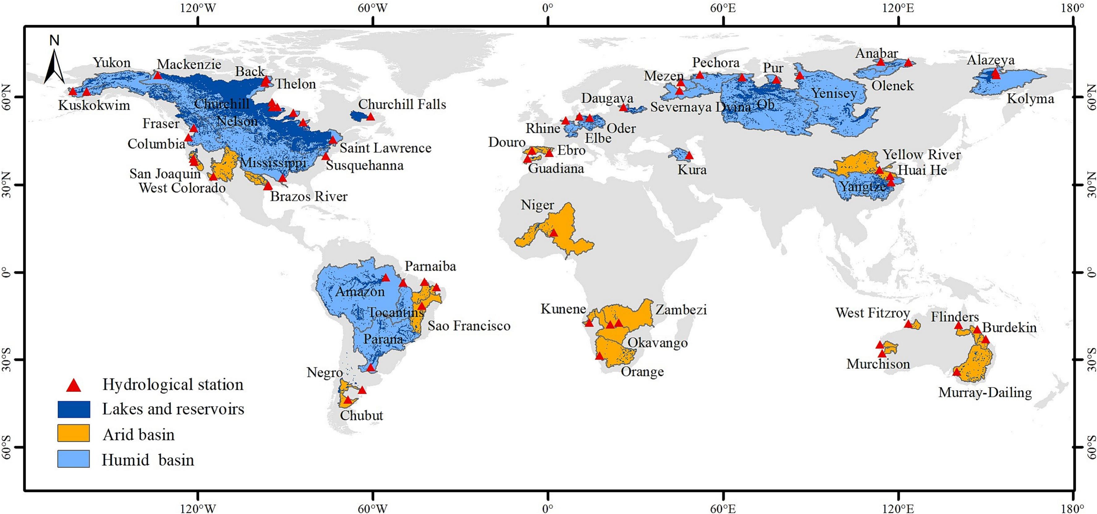
Spatial distribution of the selected basins
Monthly 0.05° winter months snow depth dataset for the Northern Hemisphere from 21 CMIP6 models
2025Scientific Data 12(1), 603
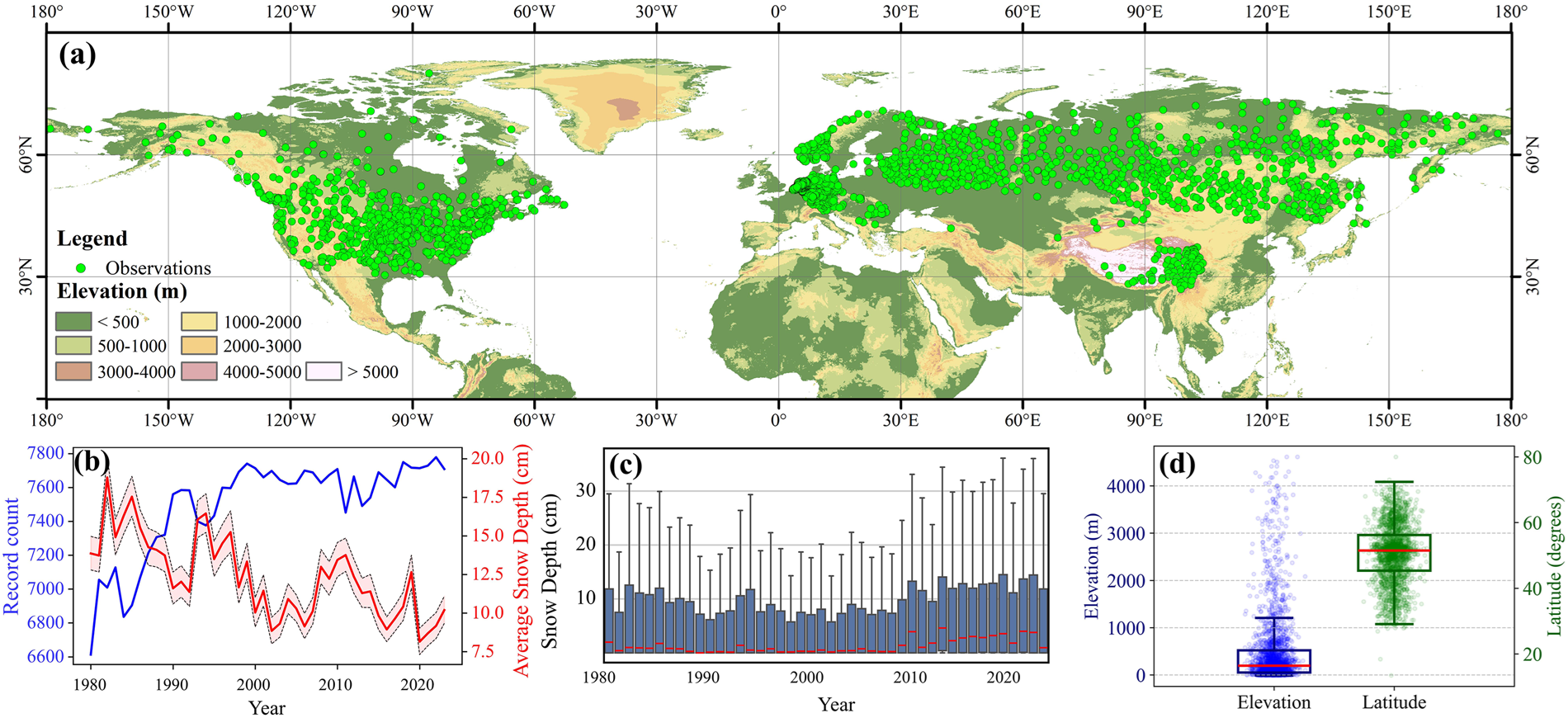
(a) Spatial distribution of the observations. (b) Number of records and snow depth. (c) Snow depth distribution during winter. (d) Distribution of elevation and latitude.
A novel method for correcting water budget components and reducing their uncertainties by optimally distributing the imbalance residual without full closure
2025Hydrol. Earth Syst. Sci. 29 (18):4607-4635
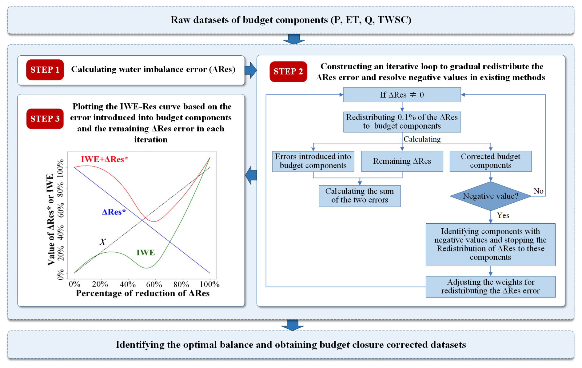
Framework of the IWE-Res method to identify the optimal balance for redistributing the ΔRes error.
A century-long streamflow reconstruction reveals significant streamflow increases in the upper Yangtze River basin
2025Catena 250, 108774
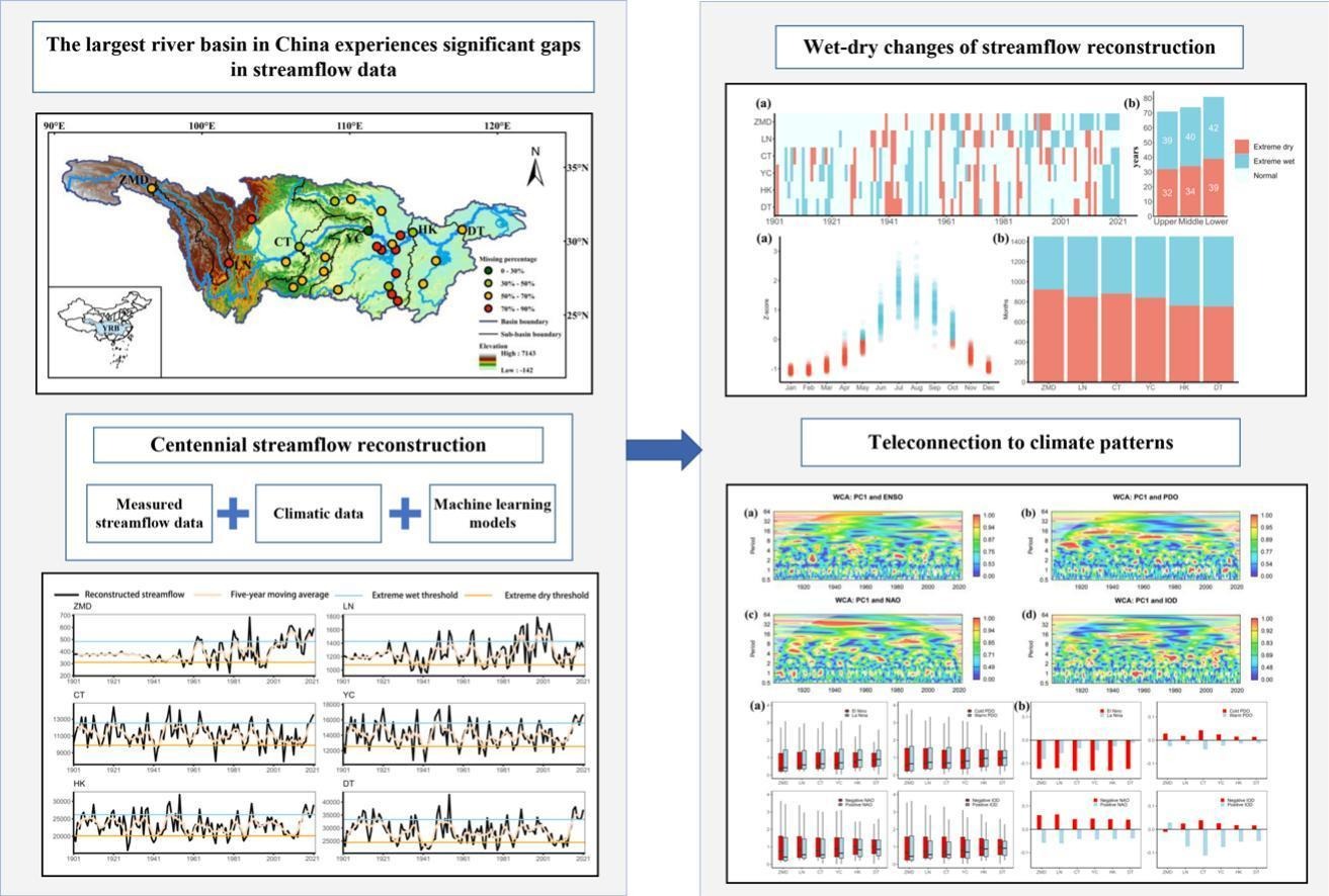
Reconstructing 121 years of monthly streamflow data (1901–2021)
150-year daily data (1870–2021) in lakes and rivers reveals intensifying surface water warming and heatwaves in the Pannonian Ecoregion (Hungary)
2024Journal of Hydrology: Regional Studies 56, 101985
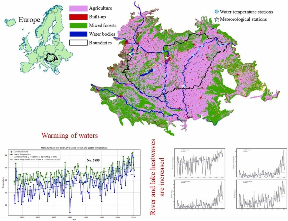
Waters show clear warming trend, especially in recent three to four decades
Exploring spatiotemporal features of surface water temperature for Lake Balaton in the 21st century based on Google Earth Engine
2024Journal of Hydrology 640, 131672
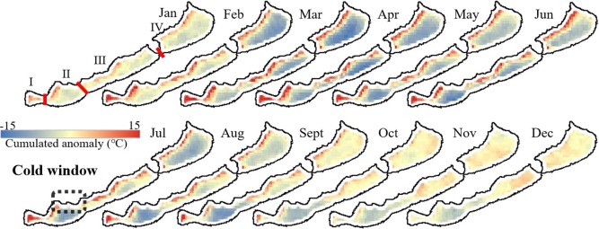
The cumulated temperature anomaly from the daily mean temperature in each month
Exploring the topographical pattern beneath the water surface: Global Bathymetric Volume-Area-Height curves (BVAH) of inland surface water bodies
2024Geodesy and Geodynamics 15 (6):602-615
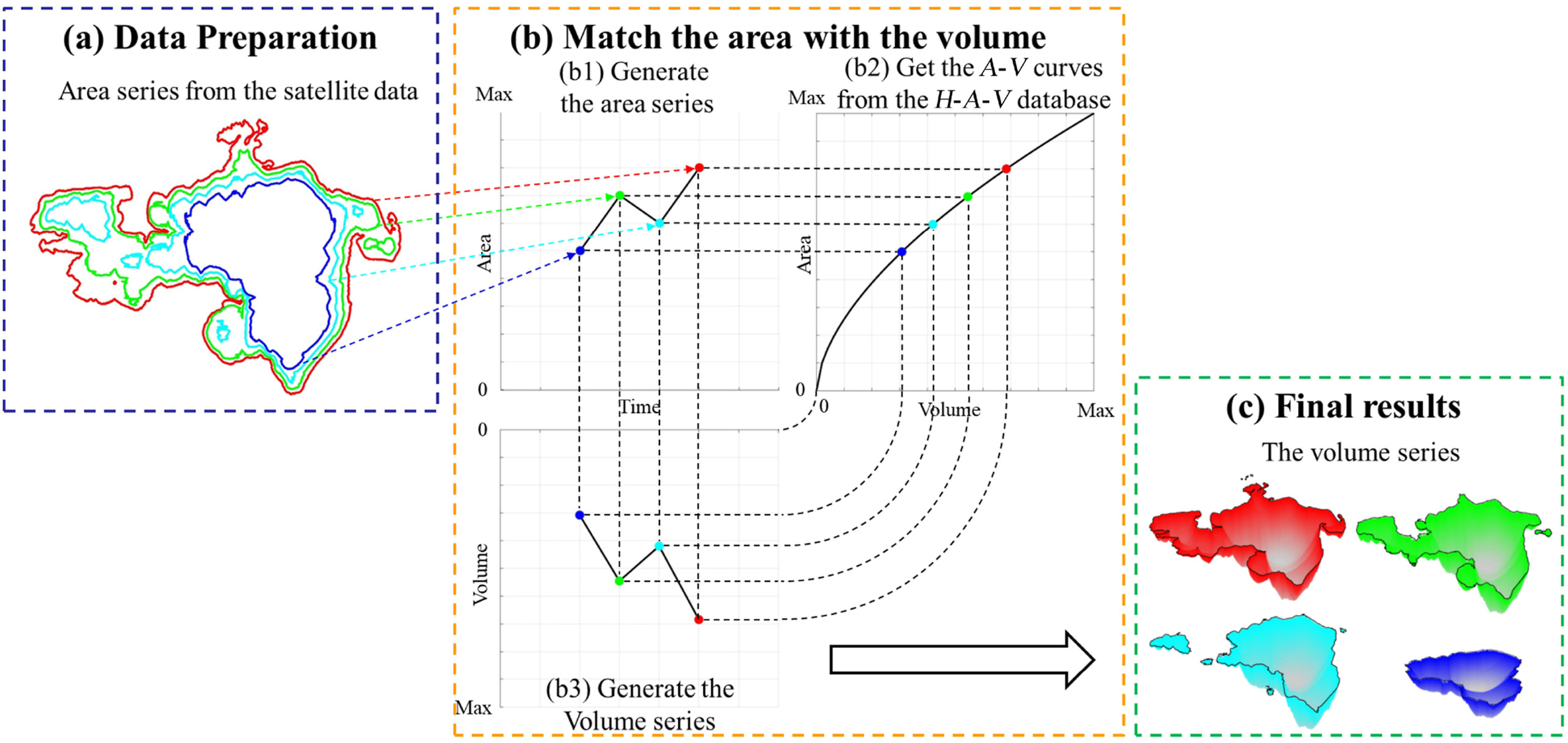
The procedures for generating the volumes series based on the area series and hydrological curves
Inspects and prospects of satellite remote sensing monitoring ability for land surface water in China
2023National Remote Sensing Bulletin 27 (7):1554-1573
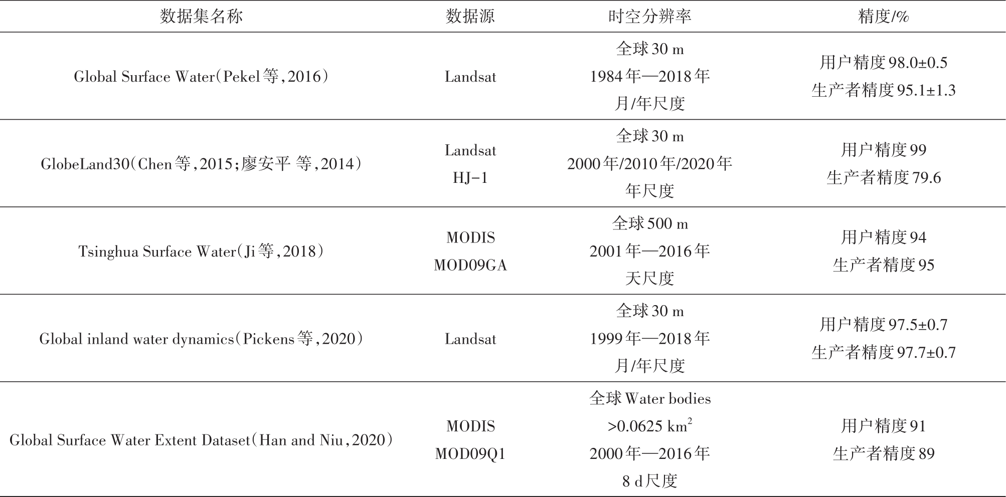
Area datasets for long-term global surface water bodies
A remote sensing-based area dataset for approximately 40 years that reveals the hydrological asynchrony of Lake Chad based on Google Earth Engine
2021Journal of Hydrology 603, 126934
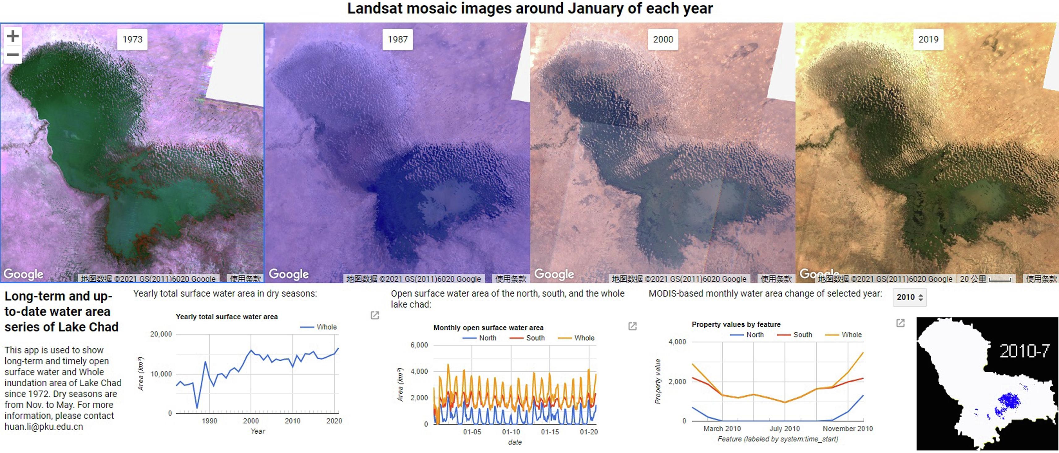
Interactive application interface for long-term and up-to-date area inspections of Lake Chad
Improving the Evapotranspiration Estimation under Cloudy Condition by Extending the Ts-VI Triangle Model
2021Remote Sensing 13(8), 1516
DOI: 10.3390/rs13081516Distribution and Attribution of Terrestrial Snow Cover Phenology Changes over the Northern Hemisphere during 2001–2020
2021Remote Sensing 13(9), 1843
DOI: 10.3390/rs13091843Decadal variations of sea ice thickness in the Amundsen-Bellingshausen and Weddell Seas retrieved from ICESat and IceBridge laser altimetry, 2003-2017
2020Journal of Geophysical Research: Oceans 125(12), e2020JC016077
DOI: 10.1029/2020jc016077A Google Earth Engine-Enabled Software for Efficiently Generating High-Quality User-Ready Landsat Mosaic Images
2019Environmental Modelling & Software 112:16-22
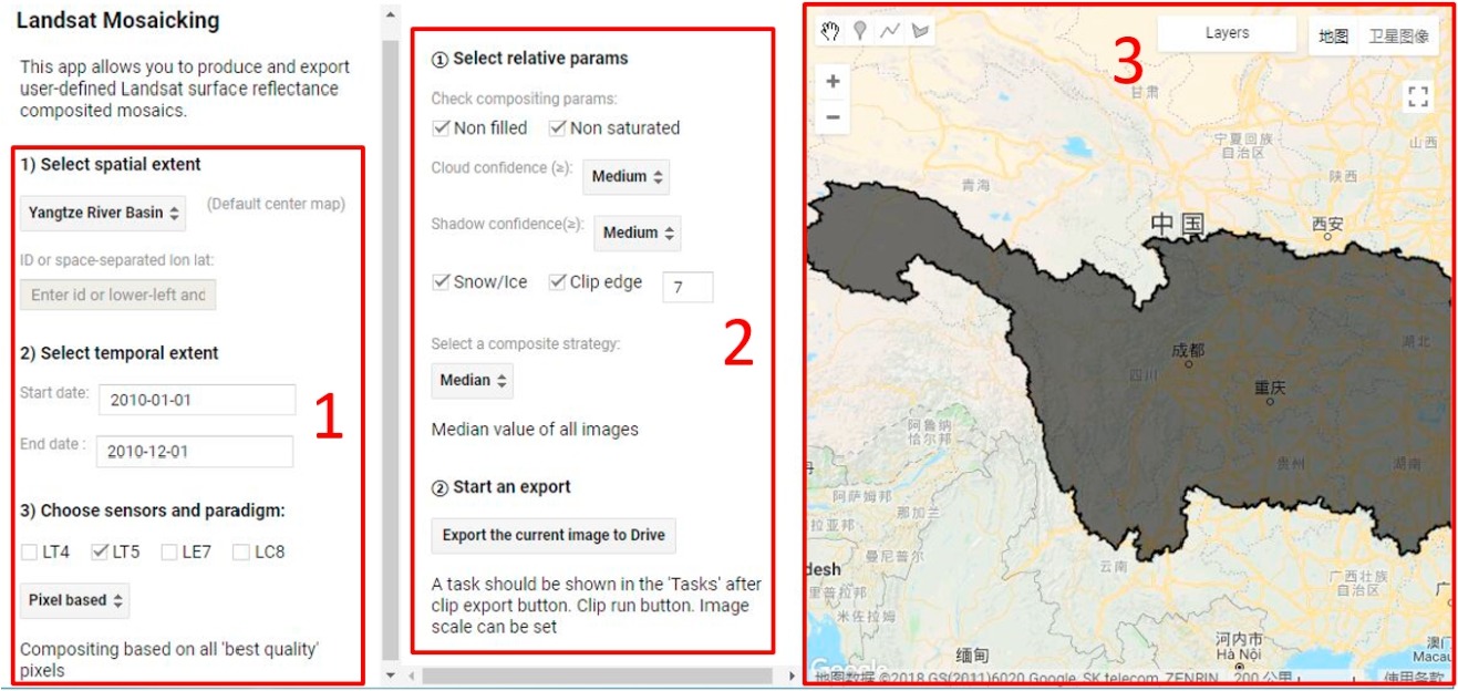
Acquiring high-quality user-defined Landsat composited mosaic images under GEE cloud environment
Assessment of Water Storage Change in China's Lakes and Reservoirs over the Last Three Decades
2019Remote Sensing 11(12), 1467
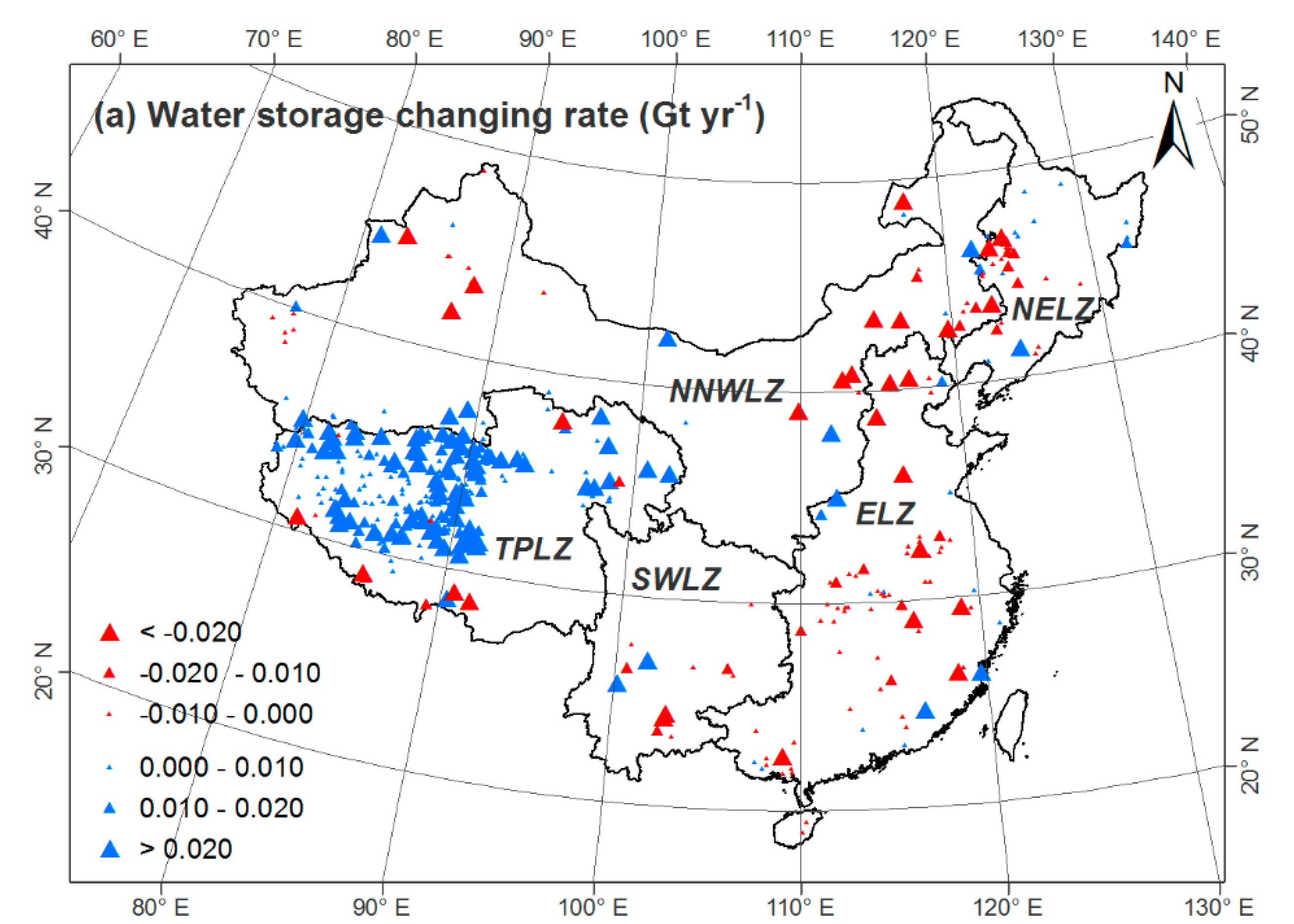
Spatial distribution of water storage change in lakes and reservoirs, 1984–2015
Spatio-temporal variability of Antarctic sea-ice thickness and volume obtained from ICESat data using an innovative algorithm
2018Remote Sensing of Environment 219, 44-61
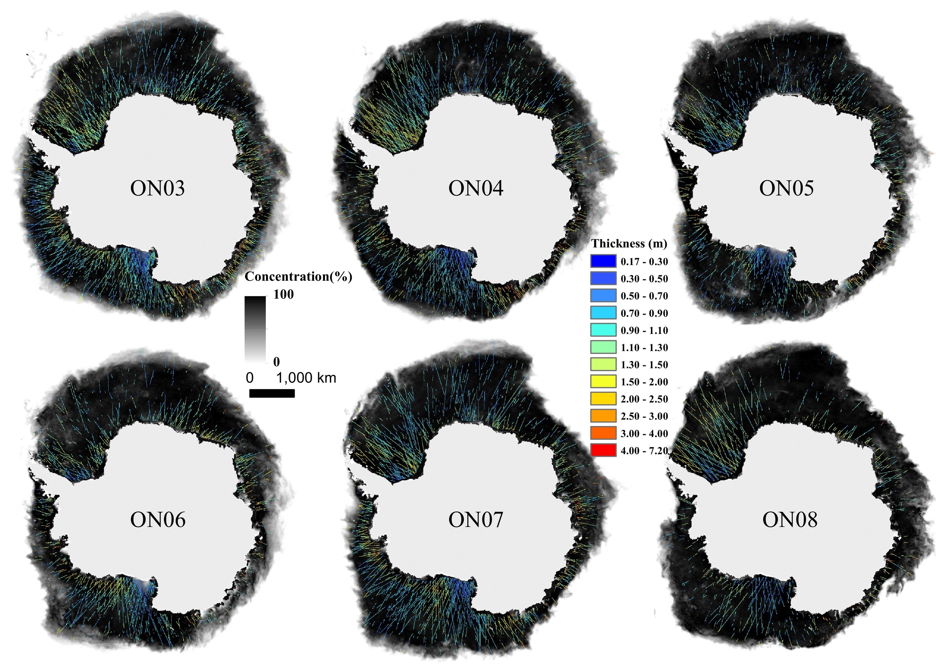
Sea-ice concentration and ICESat OLM algorithm sea-ice thickness in spring
A Visualization Approach to Air Pollution Data Exploration—A Case Study of Air Quality Index (PM2.5) in Beijing, China
2016Atmosphere 7(3), 35
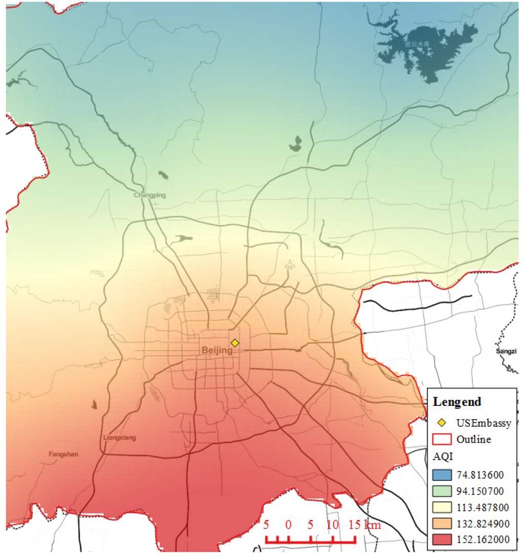
Average AQI Heatmap of PM2.5 from November 2013 to February 2014 in Beijing
Pull-Based Modeling and Algorithms for Real-Time Provision of High-Frequency Sensor Data from Sensor Observation Services
2016ISPRS International Journal of Geo-Information 5(4), 51
DOI: 10.3390/ijgi5040051Peer-Reviewed Articles (Second/Corresponding Author)
Regime shift in microalgal dynamics: Impact of water level changes on planktonic and benthic algal biomass
2024Science of The Total Environment 929, 172351
DOI: 10.1016/j.scitotenv.2024.172351A Novel Two-Step Method for Enforcing Water Budget Closure and an Intercomparison of Budget Closure Correction Methods Based on Satellite Hydrological Products
2023Water Resources Research 59
DOI: 10.1029/2022WR032176Potential of ANN for Prolonging Remote Sensing-based Soil Moisture Products for Long-term Time Series Analysis
2022IEEE Geoscience and Remote Sensing Letters 19
DOI: 10.1109/lgrs.2021.3140113Deriving Antarctic Sea‐Ice Thickness From Satellite Altimetry and Estimating Consistency for NASA's ICESat/ICESat‐2 Missions
2021Geophysical Research Letters e2021GL093425
DOI: 10.1029/2021gl093425A comprehensive data set of lake surface water temperature over the Tibetan Plateau derived from MODIS LST products 2001-2015
2017Scientific Data 4, 170095
DOI: 10.1038/sdata.2017.95Peer-Reviewed Articles (Co-Author)
A New Approach to Identifying and Analyzing Precipitation Events and Their Typical Lifecycles Over Conterminous United States
2025Geophysical Research Letters 52(14), e2025GL115640
DOI: 10.1029/2025GL115640Utilizing Multi-Source Datasets for the Reconstruction and Prediction of Water Temperature in Lake Miedwie (Poland)
2024Remote Sensing 16(15), 2753
DOI: 10.3390/rs16152753Statistical Analysis of CyGNSS Speckle and Its Applications to Surface Water Mapping
2022IEEE Transactions on Geoscience and Remote Sensing 60, 1-15
DOI: 10.1109/TGRS.2022.3196012A new method for assessing satellite-based hydrological data products using water budget closure
2021Journal of Hydrology 594, 125927
DOI: 10.1016/j.jhydrol.2020.125927A Two-Step Method to Calibrate CYGNSS-Derived Land Surface Reflectivity for Accurate Soil Moisture Estimations
2020IEEE Geoscience and Remote Sensing Letters
DOI: 10.1109/LGRS.2020.3023650Recognizing Global Reservoirs From Landsat 8 Images: A Deep Learning Approach
2019IEEE Journal of Selected Topics in Applied Earth Observations and Remote Sensing
DOI: 10.1109/JSTARS.2019.2929601A long-term dataset of lake surface water temperature over the Tibetan Plateau derived from AVHRR 1981–2015
2019Scientific Data 6(1), 48
DOI: 10.1038/s41597-019-0040-7A New Digital Lake Bathymetry Model Using the Step-Wise Water Recession Method to Generate 3D Lake Bathymetric Maps Based on DEMs
2019Water 11(6), 1151
DOI: 10.3390/w11061151Construct Channel Network Topology from Remote Sensing Images by Morphology and Graph Analysis
2019IEEE Geoscience and Remote Sensing Letters
DOI: 10.1109/LGRS.2019.2942107Lake surface water temperature change over the Tibetan Plateau from 2001–2015: A sensitive indicator of the warming climate
2018Geophysical Research Letters 45(20), 11177
DOI: 10.1029/2018gl078601An Efficient and Effective Approach for Georeferencing AVHRR and GaoFen-1 Imageries Using Inland Water Bodies
2018IEEE Journal of Selected Topics in Applied Earth Observations and Remote Sensing 11(7), 2491-2500
DOI: 10.1109/JSTARS.2018.2833627Positioning Locality Using Cognitive Directions Based on Indoor Landmark Reference System
2018Sensors, 1049
DOI: 10.3390/s18041049Book Chapters
Dynamic correlation analysis of the stock markets of China and United States based on big financial system data
2017In "Practical Case Study of Big Data in Financial Industry," Editor Liu, S. Economic Science Press: 145-164 (In Chinese)
Conference Proceedings
Retrieving chlorophyll-a concentration for lake Balaton with Landsat based on Google Earth Engine
2023IEEE Geoscience and Remote Sensing Symposium (IGARSS)
Ship Navigation Route Planning Using Topology of Sea Ice Channels Extracted from High Resolution Satellite Images
2020IEEE Geoscience and Remote Sensing Symposium (IGARSS)
DOI: 10.1109/IGARSS39084.2020.9324159A Remote Sensing-based Vacancy Area Index for Estimating Housing Vacancy and Ghost Cities in China
2019IEEE International Geoscience and Remote Sensing Symposium (IGARSS)
DOI: 10.1109/IGARSS.2019.8898197Can Crowdsourcing Support Remote Sensing Image Classification?
2018The 26th International Conference on GeoInformatics
DOI: 10.1109/GEOINFORMATICS.2018.8557144The relationship between cigarette sales and the economy in Guizhou province
20162016 Fifth International Conference on Agro-Geoinformatics
DOI: 10.1109/Agro-Geoinformatics.2016.7577624An on-demand provision model for geospatial multisource information with active, self-adaption services
20152015 SPIE Ninth International Symposium on Multispectral Image Processing and Pattern Recognition
ReSDaP: A Real-Time Data Provision System Architecture for Sensor Webs
20142014 Web and Wireless Geographical Information Systems, Springer: 85-99